Arrowhead Provincial Park
|
Rating: ★★★★★★★★★☆ Arrowhead
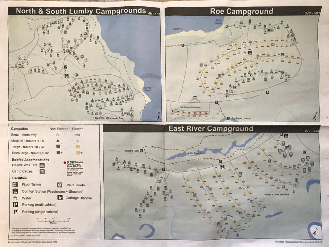
451 Arrowhead Park Rd, Huntsville, ON P1H 2J4 (705) 789-5105 No. of Sites (377) - 191 non-electrical sites, 186 electrical sites, 0 group sites Wheel Chair Accessible Campsites - no, but there are barrier free showers and washrooms stalls at all comfort stations. Operating Dates: May 11, 2018 to October 9, 2018 |
Blog Entries: - Toad the Fast Rocket and Dobson the Fly - July 2018
- Swimming Squirrel - July 2018
- In A Cabin, In The Woods -November 2020
- Swimming Squirrel - July 2018
- In A Cabin, In The Woods -November 2020
Terrain: Plenty of mixed deciduous and and coniferous trees that provide plenty of shade and plenty of privacy. The forest contains sugar maples,
yellow birch, poplar, beech, white pine, hemlock, balsam fir, and white spruce.
In Roe Campground there is the presence of Poison Ivy. It is mostly around the Loops of the roads and a few pathways that lead to the
beach or other roads. There are signs posted where it is prevalent in the area. Poison Ivy is not found in the rest of the park.
Some sites in the East River campground are close to Stubbs Falls..
Staff: Personable and pleasant
Bathrooms: Clean, vault toilets
Shower: Yes, at the comfort stations located centrally in each campground. Hot water. Clean.
Beach: Three, medium to large, sandy beaches on Arrowhead Lake. The beach in the East River campground is also a designated day use beach
so it tends to be busier. The beach near Roe campground is less crowded and offers great access for fishing.
Outdoor Water Faucets: Plenty of them, easy to find and good, clean drinking water
Hiking Trails:
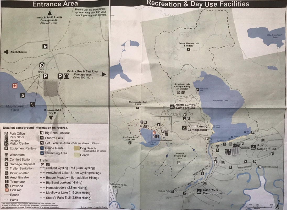
Beaver Meadow Trail - 7 km (2 hours) moderate
Arrowhead’s longest trail passes Porcupine Bluffs, the remnant shoreline of a huge ancient lake. The bluffs are easily visible in the spring and fall but are hidden during the leafy summer months. The trail circles a large beaver pond with large rafts of cattails where you might see otter, moose, Great Blue Heron, Tree Swallows and, of course, beavers. Near the end, the trail crosses a field and you can see evidence of the once successful Oke homestead—old fence lines, building foundations and domestic plants such as rhubarb and apple trees.
Big Bend Lookout – easy
This short walk from the parking lot on Roe Campground Road leads to a panoramic view of the meandering Big East River and the surrounding Muskoka terrain.
Homesteaders Trail - 3 km (1 hour) moderate
In the 1870s, homesteaders cleared this area. Take this trail across moderately rugged terrain and see traces of abandoned farm fields now reclaimed by young forest.
Mayflower Lake Trail – 1 km (30 minutes) moderate
Ten thousand years ago, Mayflower Lake was a small bay in a large glacial lake. Today it is a small, deep, spring-fed lake. Its cold, clear waters provide ideal habitat for cold water fish such as Rainbow Trout. This trail has several lengthy climbs and descents over the hills surrounding Mayflower Lake and can be muddy, so wear your hiking boots.
Stubb’s Falls Trail - 2 km (45 minutes) easy
Take this trail in early spring when wildflowers and songbirds will be your reward. At Stubb’s Falls, the Little East River rushes down a rock chute. Stop here for a pleasant respite.
Your browser does not support viewing this document. Click here to download the document.
Pet Amenities: The dog beach is located nearest to the north Lumby Campground. Dogs can be walked there without a leash. There is also a small
area near the main beach (both sides of the bridge) where dogs can swim.
Playground: none
Park Store: The park store is in a large building located close to Mayflower lake and is where some of the hiking trails start. Offers groceries,
snacks, candy, locally baked goods, Kawartha Dairy products, ice cream, camping supplies, and some lovely souvenirs.
Rentals: Canoes, kayaks and bicycles can be rented from the Beach Information Building at the day-use beach. There are also PFDs
and helmets available to rent. In the winter months the main gate rents cross-country ski equipment, snowshoes and skates.
Your browser does not support viewing this document. Click here to download the document.
Your browser does not support viewing this document. Click here to download the document.
Things To Do At Arrowhead Provincial Park
- Fishing
- Swimming
- Canoeing (motorized boats are prohibited on both Arrowhead lake and Mayflower lake)
- Birding
- Hiking
- Natural HeritageEducation
- Biking
- Picnicking (A group picnic shelter in the day-use area accommodates 50 – 100 people and can be reserved for birthday parties, reunions,
gatherings or any other special event).
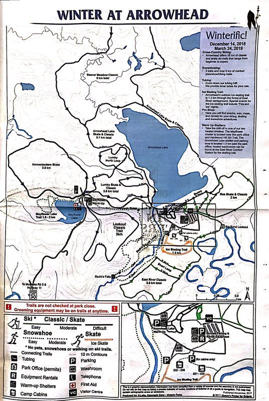
- Winter hiking
- Snowshoeing
- Cross-country skiing
- Skate skiing
- the Annual Muskoka Loppet
- Skating trail
- Skating rink
- Tubing (There are two warm-up shelters and an open fire pit at the top of the tubing hill - Tubes provided! )
Attractions And Places To Go Near Arrowhead Provincial Park
Closest City (town) - Huntsville, Ontario
- Treetop Trekking (zip lining)
- Live At Deerhurst Stage Shows
- Bush Poker Ax Throwing Muskoka (83 Morgans Rd off Highway 60, ten minutes east of Huntsville)
- Muskoka Hot Yoga
- Huntsville Bowl
- Zig Zag Escape Rooms
- HP-eh Paintball
- Algonquin Theatre
- Group of Seven Outdoor Gallery
- Muskoka Heritage Place
- Sugarbush Hill Maple Farm
- Huntsville Downs Gold Course
Directions:
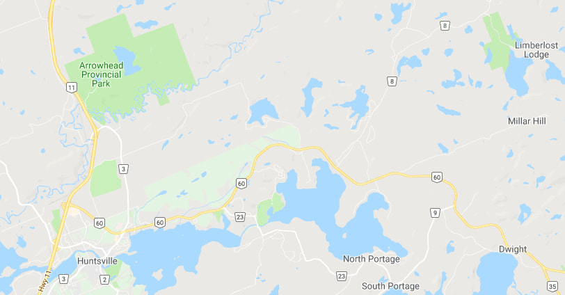
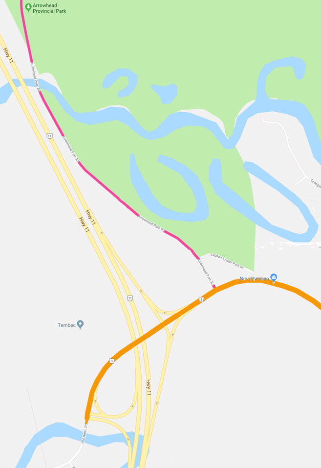
Arrowhead Provincial Park can be accessed by Highway 11, which runs north-south, between Toronto and North Bay. Exit from Highway 11 at Muskoka Road 3 North and turn left onto Arrowhead Park Road.
Signs For Directions To Park - If you are traveling south it is easier to see the signs than it is to get there. Back in the day, the park was directly off the highway. But then they rerouted the highway and that made access coming from the north more difficult. Coming from that direction, when you see the sign you have to drive past the park, exit onto highway 3, turn left onto Arrowhead Park Road and drive back up north a little ways (see dark pink road on map below) to the park entrance. Seems a little counter intuitive, but it works.
