Esker Lakes Provincial Park
|
Rating: ★★★★★★★★☆☆ Esker Lakes
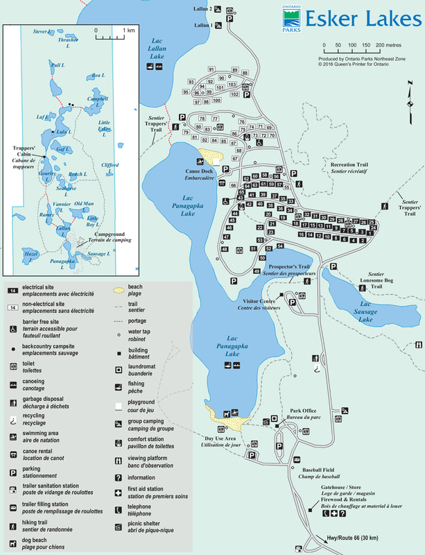
Highway 672, Kirkland Lake, ON, P2N 3K4 705-568-7677 (summer) 705-272-7107 (winter) No. of Sites (103) - 39 non-electrical sites, 64 electrical sites, 3 group sites Wheel Chair Accessible Campsites - Two - sites # 73 and 43. Operating Dates: May 17, 2019 to September 2, 2019 |
Blog Entries: - Free To Enjoy The Day And The Dragonflies (August 2019)
- The Lonesome Bog (August 2019)
- What Looks Like A Sandpiper But Is Not A Sandpiper? (August 2019)
- The Lonesome Bog (August 2019)
- What Looks Like A Sandpiper But Is Not A Sandpiper? (August 2019)
Terrain: A Boreal forest surrounding dozens of kettle lakes. It is part of the famous 250-kilometre Munroe esker with undulating hills, sand
dunes and bog. Most of the area has been dramatically affected by forest fires in the years 1875, 1910, 1925, and 1940. Due to the fires,
Jack Pine is a dominant tree here because they need the high temperatures of the fire to open the pine cones and release the seeds.
There is also Black Spruce, Tamarack, White Birch and Aspen..
Staff: Personable and pleasant and very helpful
Bathrooms: Clean, vault toilets
Shower: Yes, at the two comfort stations (one near the electrical sites and one near the non-electrical sites). There is hot water but you have to
continuously move or it will shut itself off. The shower stalls are not very clean.
Beach: Two beaches, one is a designated day use beach which doubles as a pet beach. The other is closer to the campsites.
Outdoor Water Faucets: Plenty of them, but they blend in with the trees and are not always easy to find. Good, clean drinking water
Hiking Trails:
Prospector’s Trail: 1.4 km, 1 hour, easy
This short forested trail skirts the southeast shore of Panagapka Lake. It’s a nice route for a stroll and a convenient way to reach many park facilities.
Lonesome Bog Trail: 1.5 km, 1 hour, easy
This picturesque trail encircles Sausage Lake, including the bog at the east end, via a boardwalk that takes you right across the wetland. Beaver are helping to speed the bog’s transition to a meadow.
Recreation Trail: 1.5 km, 1 hour, easy
This short, meandering trail through the trees, just east of the campground is convenient and an invigorating route for a brisk walk or run.
Trapper’s Trail: three loops 9 km, 14 km and 20 km, 4 hours to two days, difficult
The Trapper’s Trail offers three loops to choose from in order to best suit your fitness level and available time. This long hiking and backpacking trail begins at the north end of Panagapka Lake and continues north towards Thrasher Lake. The trapper’s cabin on the trail was built by an Ojibway woman who trapped in the area until 1970.
Pet Amenities: The dog beach is located at the Day Use area at the south end of Panagapka Lake.
Playground: One at the beach at the north end of Panagapka Lake which is closest to the campsites
Park Store: The park store is in the gatehouse. Offers ice cream, firewood, ice, hot coffee, Ontario Parks merchandise and other amenities.
Rentals: Personal floatation devices, canoes, kayaks, paddle boats, stand-up paddleboards, trailer storage and a picnic shelter. The park participates in a Tackleshare program and provides fishing rods and tackle free to visitors.
Things To Do At Esker Lakes Provincial Park
- Fishing
- Swimming
- Canoeing
- Birding
- Hiking
- Backpacking
- Biking
- Picnicking
- Fishing
- Swimming
- Canoeing
- Birding
- Hiking
- Backpacking
- Biking
- Picnicking
Attractions And Places To Go Near Esker Lakes Provincial Park
Closest City (town) - Kirkland Lake, Ontario
- Museum of Northern History
- Heritage North
- Kirkland Lake Golf Club
- Dream Acres Alpacas in Matheson
- Thornloe Cheese Factory
- Polar Bear Habitat & Heritage Village in Cochrane
Directions:
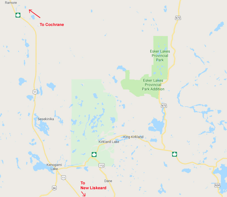
Follow Trans-Canada Hwy 11 and then turn onto Hwy 66. Follow Hwy 66 until it reaches Hwy 672 then turn left. the park is about 20 km from there on the left hand side.
Signs For Directions To Park - There are not a lot of them and you drive for quite awhile before you see them. However, they are easy to see and easy to find.


