Sleeping Giant Provincial Park
Rating: ★★★★★★★★★★ Sleeping Giant
R.R. #1 Pass Lake, ON, P0T 2M0 (807) 977-2526
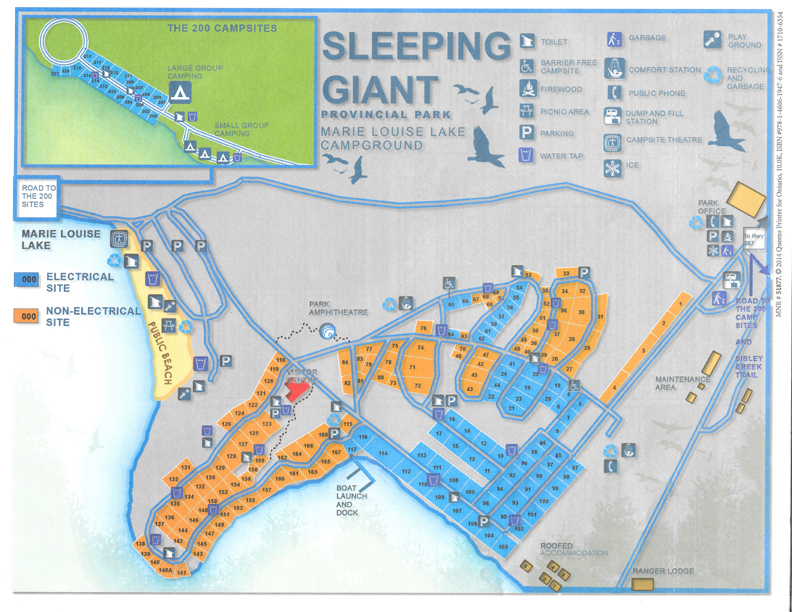
No. of Sites (240) - 115 non-electrical sites, 85 electrical sites, 2 group sites, 40 back country sites, 1 lodge (available year round) , 5 cottages(available year round),
3 trailer equipped campsites (Site Number(s): 211, 213, 215 - Sleeps 6)
Wheel Chair Accessible Campsites - There are 2 barrier-free campsite (sites # 65E and #6)
R.R. #1 Pass Lake, ON, P0T 2M0 (807) 977-2526
No. of Sites (240) - 115 non-electrical sites, 85 electrical sites, 2 group sites, 40 back country sites, 1 lodge (available year round) , 5 cottages(available year round),
3 trailer equipped campsites (Site Number(s): 211, 213, 215 - Sleeps 6)
Wheel Chair Accessible Campsites - There are 2 barrier-free campsite (sites # 65E and #6)
Blog Entries: The Sleeping Giant - August 2014
Terrain - Well treed, good balance of shade and sunshine. Far away from the nearest highway and it is so quiet and peaceful. Plenty of wildlife to be seen.
Staff - Excellent staff. Staff members went to each and every campsite to ask how people were doing and to make sure that everyone was happy and having a good time.
Bathrooms - 2 comfort stations (flush toilets/ running water), laundry facilities. Very clean and well maintained
Showers - 2
Beach - large sandy beach , large grassy area, campsite theater
Out Door Water Faucets - 21 with signs to indicate where they are.
Hiking Trails - Burma Trail (11.4 km)
- Head Trail (1 km )
- Gardner Lake Trail (4 km, return)
- Joe Creek Nature Trail (1.6 km, return) - follows Joe Creek down a series of small waterfalls from Highway 587 to Lake Superior.
- Kabeyun Trail - (40 km, strenuous) - Ideal for overnight backpacking as well as shorter, day hikes,
- Middlebrun Bay Trail and Finlay Bay Trail - (4.2 km, easy) - This hike takes you to a secluded sandy beach at Middlebrun Bay
- Pickerel Lake Trail (10 km)
- Piney Wood Hills Trail (1.4 km) - this trail ends at a viewpoint over Joeboy Lake.
- Plantain Lane Trail (0.5 km) - A section of the old abandoned Silver Islet Road takes you over a small bridge on Sibley Creek.
- Ravine Lake Trail (1.5 km return) - This trail climbs steadily to two lookouts over Grassy Lake and the peninsula’s south coast
- Sawbill Lake Trail (2.3 km) - This trail is part of an old logging road and provides access to Sawyer Bay
- Sawyer Bay Trail (6 km ) This abandoned logging road leads to Sawyer Bay at the base of the Sleeping Giant.
- Sibley Creek Trail (1.7 km return)
- Sifting Lake Trail (4 km return)
- Talus Lake Trail (6 km)
- Thunder Bay Bogs Trail (0.8 km return)
- Twinpine Lake Trail (4.7 km)
- Wildlife Habitat Trail (2.4 km return)
- Sea Lion Trail (0.5 km from Kabeyun Trail)
- Top of the Giant Trail (2.7 km challenging) - Takes you to the top of the Sleeping Giant. This hike should only be started by those in good physical condition. Bring water, sturdy hiking boots, warm clothing and a first aid kit.
Pet Amenities - none
Playground - 2 at the beach area
Visitor Centre - A beautiful multi-level building with many wonderful displays, and a live turtle in a tank in the window area.
Park Store - WestWind Store is located in the Visitor Centre and is operated by the Friends of Sleeping Giant Park. .
Boat/Canoe Rentals - canoe and kayak rentals are available at the park store
Staff - Excellent staff. Staff members went to each and every campsite to ask how people were doing and to make sure that everyone was happy and having a good time.
Bathrooms - 2 comfort stations (flush toilets/ running water), laundry facilities. Very clean and well maintained
Showers - 2
Beach - large sandy beach , large grassy area, campsite theater
Out Door Water Faucets - 21 with signs to indicate where they are.
Hiking Trails - Burma Trail (11.4 km)
- Head Trail (1 km )
- Gardner Lake Trail (4 km, return)
- Joe Creek Nature Trail (1.6 km, return) - follows Joe Creek down a series of small waterfalls from Highway 587 to Lake Superior.
- Kabeyun Trail - (40 km, strenuous) - Ideal for overnight backpacking as well as shorter, day hikes,
- Middlebrun Bay Trail and Finlay Bay Trail - (4.2 km, easy) - This hike takes you to a secluded sandy beach at Middlebrun Bay
- Pickerel Lake Trail (10 km)
- Piney Wood Hills Trail (1.4 km) - this trail ends at a viewpoint over Joeboy Lake.
- Plantain Lane Trail (0.5 km) - A section of the old abandoned Silver Islet Road takes you over a small bridge on Sibley Creek.
- Ravine Lake Trail (1.5 km return) - This trail climbs steadily to two lookouts over Grassy Lake and the peninsula’s south coast
- Sawbill Lake Trail (2.3 km) - This trail is part of an old logging road and provides access to Sawyer Bay
- Sawyer Bay Trail (6 km ) This abandoned logging road leads to Sawyer Bay at the base of the Sleeping Giant.
- Sibley Creek Trail (1.7 km return)
- Sifting Lake Trail (4 km return)
- Talus Lake Trail (6 km)
- Thunder Bay Bogs Trail (0.8 km return)
- Twinpine Lake Trail (4.7 km)
- Wildlife Habitat Trail (2.4 km return)
- Sea Lion Trail (0.5 km from Kabeyun Trail)
- Top of the Giant Trail (2.7 km challenging) - Takes you to the top of the Sleeping Giant. This hike should only be started by those in good physical condition. Bring water, sturdy hiking boots, warm clothing and a first aid kit.
Pet Amenities - none
Playground - 2 at the beach area
Visitor Centre - A beautiful multi-level building with many wonderful displays, and a live turtle in a tank in the window area.
Park Store - WestWind Store is located in the Visitor Centre and is operated by the Friends of Sleeping Giant Park. .
Boat/Canoe Rentals - canoe and kayak rentals are available at the park store
Things To Do At Sleeping Giant Provincial Park
- Fishing
- Swimming
- Self Guided trails
- Picnicking
- Natural Heritage Education (in July and August)
- Visitor Centre
- Canoeing
- Kayaking
- Birding
- cross-country skiing
- Sleeping Giant Loppet (first Saturday in March)
- snowshoeing
- Fishing
- Swimming
- Self Guided trails
- Picnicking
- Natural Heritage Education (in July and August)
- Visitor Centre
- Canoeing
- Kayaking
- Birding
- cross-country skiing
- Sleeping Giant Loppet (first Saturday in March)
- snowshoeing
Attractions And Places To Go Near McRae Point Provincial Park
Closest City - Thunder Bay, Ontario
- Amethyst Mine Panorama (pick your own amethysts)
- Amethyst Gift Centre
- Aeosports' World Class Wall-to-Wall Trampoline Park
- Paintball Mountain
- Fort William Historical Park
- Chippewa Park & Wildlife Exhibit
- Founder's Museum and Pioneer Village
Closest City - Thunder Bay, Ontario
- Amethyst Mine Panorama (pick your own amethysts)
- Amethyst Gift Centre
- Aeosports' World Class Wall-to-Wall Trampoline Park
- Paintball Mountain
- Fort William Historical Park
- Chippewa Park & Wildlife Exhibit
- Founder's Museum and Pioneer Village
Directions:
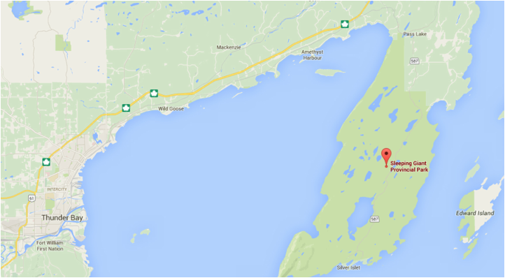
From Thunder Bay, travel E on Hwy 11/17 toward Sault Ste. Marie. At the Pass Lake turn (there is gas station on the left side of the highway), turn right onto Secondary Highway 587 to Pass Lake.
Signs For Directions To Park - Easy to see and easy to find. Look for the big sign with foxes on the right side of road that says "Marie Louise Lake"
From Thunder Bay, travel E on Hwy 11/17 toward Sault Ste. Marie. At the Pass Lake turn (there is gas station on the left side of the highway), turn right onto Secondary Highway 587 to Pass Lake.
Signs For Directions To Park - Easy to see and easy to find. Look for the big sign with foxes on the right side of road that says "Marie Louise Lake"