Kap-Kig-Iwan Provincial Park
|
Rating: ★★★☆☆☆☆☆☆☆ Kap-Kig-Iwan
2-4 Highway 11 South, PO Box 730, Cochrane, P0L 1C0 705-544-2050 (May - August only) 705-544-1968 (the rest of the year) No. of Sites (61) - 39 non-electrical sites, 22 electrical sites, 0 group sites Wheel Chair Accessible Campsites - one barrier free campsite. Operating Dates: May 17, 2019 to September 22, 2019 |
Blog Entries: The Park That Time Forgot
Terrain: Kap-Kig-Iwan, although the smallest provincial park in the Northern Region, is regionally noted for its flora, fauna and geological features.
It is a quiet and restful place, small but charming. Two of the outstanding attractions of the park are its series of spectacular waterfalls and
its numerous scenic lookouts. The rushing Englehart River plunges down white-water rapids, over several cascades and waterfalls in a
picturesque valley. Black ash, balsam, poplar and elm are among the trees that are growing here.
Staff: Personable and pleasant, very friendly and flexible. If staff is not on site you can leave payment in the self serve envelopes at the office.
*NOTE: There is no wi-fi, therefore no debit or credit here. Cash only! *
Bathrooms: In need of updating. The Lower campground Loop only has a single port-a-potty available.
Shower: Yes, at the comfort stations located just past the park office. Showers are a bit shabby and the building needs some TLC.
Beach: none.
Outdoor Water Faucets: A couple at the campground that is close to the office but none at the Lower Campground Loop. I don't think the water is potable so it would be best if you bring your own water.
Hiking Trails:
Cedar Trail 4.5 km (2 hours) easy - Named for a 150-year-old cedar tree that survived a major forest fire in 1922, this trail skirts a beaver lodge and leads to a scenic view of the Englehart River.
Hell’s Gate Trail 2.5 km return (1 hour) moderate - Don’t let the ominous name put you off! The trail joins up with the Upland Circle Trail, but also includes a winding path along the Englehart River bank to see some amazing rapids, water falls and deep ravines.
Upland Circle Trail 5 km (2.5 hours) moderate - Bird watching is excellent along this trail through pine, beech and poplar stands.Take a stroll through the clifftop woods, high above the river below.
High Falls Trail - This trail follows the Englehart River past waterfalls, rapids and deep ravines. there was a bridge across the river at one point but it is falling down and is closed to the public.
Long Trail Trail 4.70 km - This trail is wide and grassy and goes through a forested area. This doubles as a ski trail in the winter.
Long Trail Trail with shortcut 3.41 km - Shorter version of the Long Trail. This trail is wide and grassy and goes through a forested area. This doubles as a ski trail in the winter.
Disney Trail 1.12 km - A small section of the Long Trail. My guess is they call it this because in the winter the Long trail is used as a ski trail and this part of the trail is probably used for kids. This trail leads to a chalet.
Small Loop - Like the Disney Trail, this is a small section of the Long Trail. It is probably also used for a kids winter ski trail. This trail leads to a chalet.
Ridge View Trail 3 km - This trail follows the Englehart River past waterfalls, rapids and deep ravines.
Nature's Trail 2.33 km - This trail runs in behind the office and joins up with the Uplands Circle Trail.
Lower Camp Trail - In the summer it is just the road to the tenting campsites. In the winter it is a ski trail. This trail runs down a steep hill and has some scenic views of the ravine.
Pet Amenities: none. But the trails are a nice place to walk a dog.
Playground: none
Park Store: none.
Rentals: none.
It is a quiet and restful place, small but charming. Two of the outstanding attractions of the park are its series of spectacular waterfalls and
its numerous scenic lookouts. The rushing Englehart River plunges down white-water rapids, over several cascades and waterfalls in a
picturesque valley. Black ash, balsam, poplar and elm are among the trees that are growing here.
Staff: Personable and pleasant, very friendly and flexible. If staff is not on site you can leave payment in the self serve envelopes at the office.
*NOTE: There is no wi-fi, therefore no debit or credit here. Cash only! *
Bathrooms: In need of updating. The Lower campground Loop only has a single port-a-potty available.
Shower: Yes, at the comfort stations located just past the park office. Showers are a bit shabby and the building needs some TLC.
Beach: none.
Outdoor Water Faucets: A couple at the campground that is close to the office but none at the Lower Campground Loop. I don't think the water is potable so it would be best if you bring your own water.
Hiking Trails:
Cedar Trail 4.5 km (2 hours) easy - Named for a 150-year-old cedar tree that survived a major forest fire in 1922, this trail skirts a beaver lodge and leads to a scenic view of the Englehart River.
Hell’s Gate Trail 2.5 km return (1 hour) moderate - Don’t let the ominous name put you off! The trail joins up with the Upland Circle Trail, but also includes a winding path along the Englehart River bank to see some amazing rapids, water falls and deep ravines.
Upland Circle Trail 5 km (2.5 hours) moderate - Bird watching is excellent along this trail through pine, beech and poplar stands.Take a stroll through the clifftop woods, high above the river below.
High Falls Trail - This trail follows the Englehart River past waterfalls, rapids and deep ravines. there was a bridge across the river at one point but it is falling down and is closed to the public.
Long Trail Trail 4.70 km - This trail is wide and grassy and goes through a forested area. This doubles as a ski trail in the winter.
Long Trail Trail with shortcut 3.41 km - Shorter version of the Long Trail. This trail is wide and grassy and goes through a forested area. This doubles as a ski trail in the winter.
Disney Trail 1.12 km - A small section of the Long Trail. My guess is they call it this because in the winter the Long trail is used as a ski trail and this part of the trail is probably used for kids. This trail leads to a chalet.
Small Loop - Like the Disney Trail, this is a small section of the Long Trail. It is probably also used for a kids winter ski trail. This trail leads to a chalet.
Ridge View Trail 3 km - This trail follows the Englehart River past waterfalls, rapids and deep ravines.
Nature's Trail 2.33 km - This trail runs in behind the office and joins up with the Uplands Circle Trail.
Lower Camp Trail - In the summer it is just the road to the tenting campsites. In the winter it is a ski trail. This trail runs down a steep hill and has some scenic views of the ravine.
Pet Amenities: none. But the trails are a nice place to walk a dog.
Playground: none
Park Store: none.
Rentals: none.
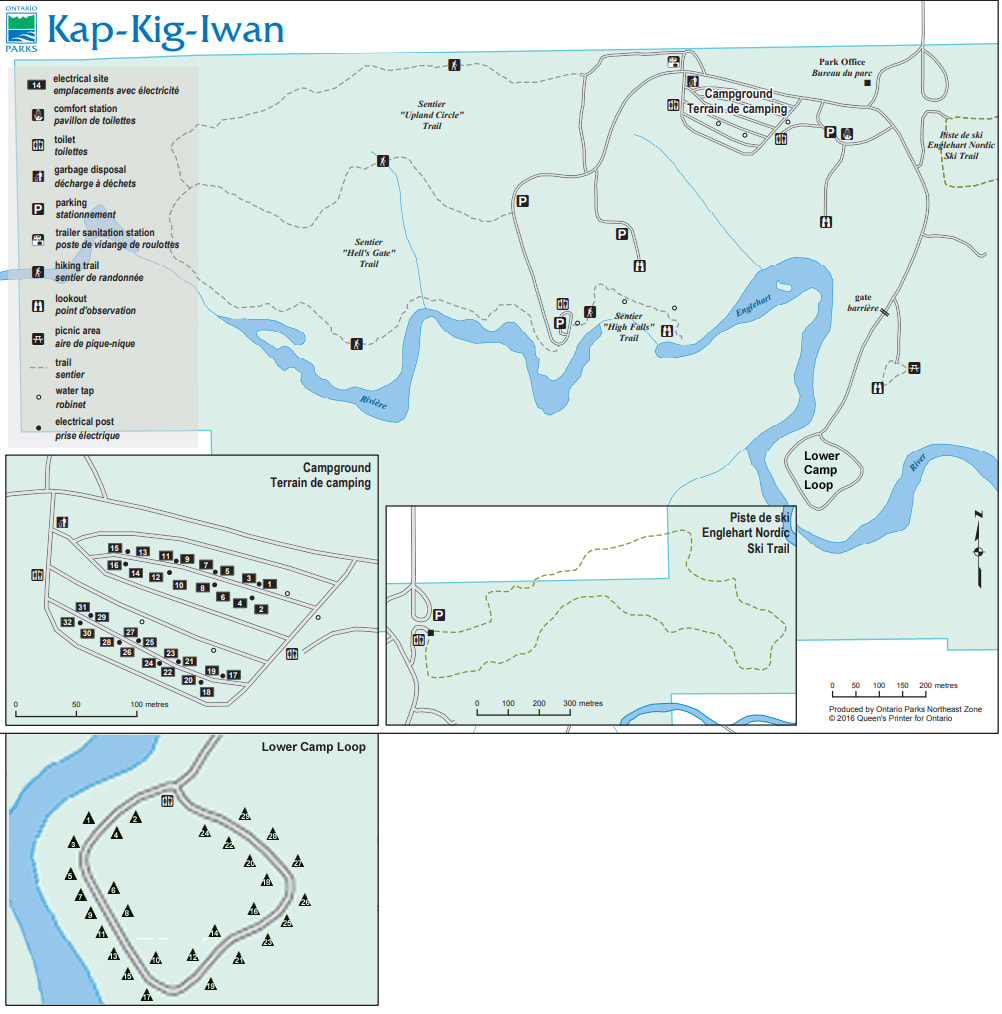
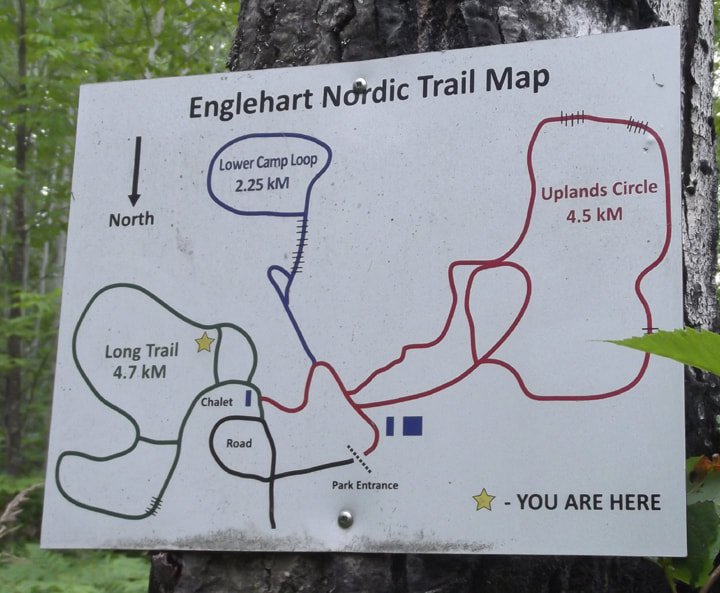
Map they give you at the gate (Cute but hard to read)
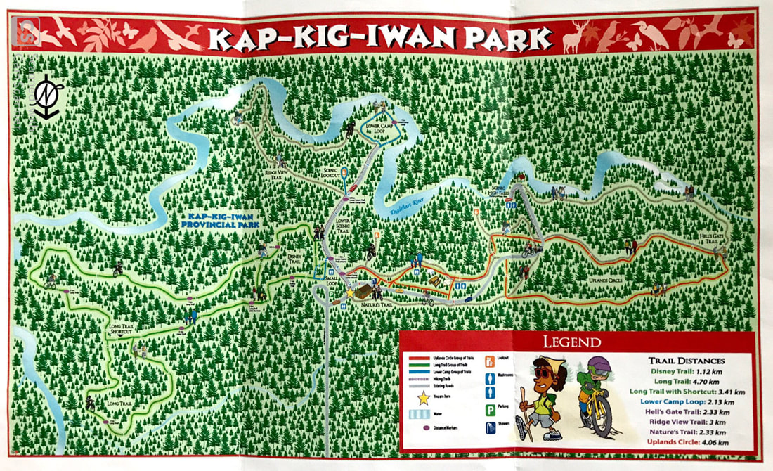
My version of the Trails Map
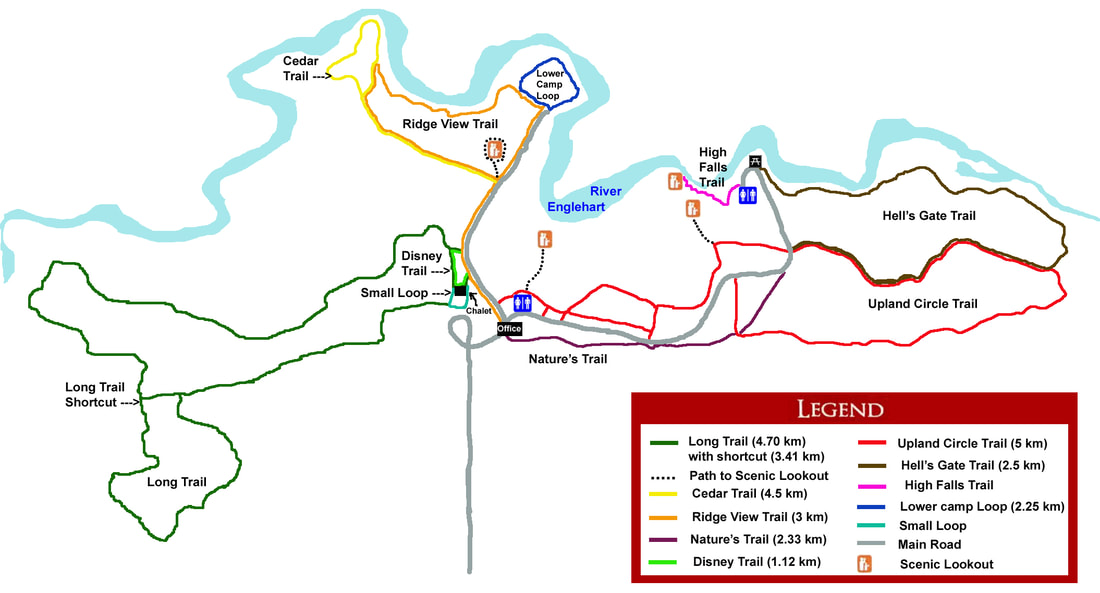
Winter Ski Trail Map
Things To Do At Kap-Kig-Iwan Provincial Park
- Birding
- Hiking
- Biking
- Picnicking (A group picnic shelter has a scenic view of the falls).
- Fishing
- Winter hiking
- Snowshoeing
- Cross-country skiing
- Birding
- Hiking
- Biking
- Picnicking (A group picnic shelter has a scenic view of the falls).
- Fishing
- Winter hiking
- Snowshoeing
- Cross-country skiing
Attractions And Places To Go Near Kap-Kig-Iwan Provincial Park
Closest City (town) - Englehart, Ontario
- Thornloe Cheese factory
- Englehart Historical Museum
- The 701 Steam Engine in Englehart
- Cobalt Mining Museum
- Devil's Rock Hiking Trail (Temiskaming Shores)
- Little Claybelt Homesteaders in New Liskeard
Closest City (town) - Englehart, Ontario
- Thornloe Cheese factory
- Englehart Historical Museum
- The 701 Steam Engine in Englehart
- Cobalt Mining Museum
- Devil's Rock Hiking Trail (Temiskaming Shores)
- Little Claybelt Homesteaders in New Liskeard
Directions:
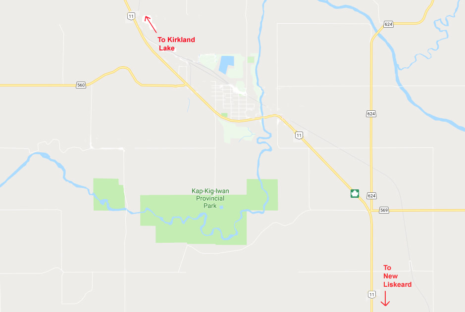
Kap-Kig-Iwan Provincial Park is situated in Northeastern Ontario, 2 km south of Englehart and 520 km north of Toronto via hwy 11.
Kap-Kig-Iwan Provincial Park is situated in Northeastern Ontario, 2 km south of Englehart and 520 km north of Toronto via hwy 11.
Signs For Directions To Park - Keep your eyes peeled or you might miss it. There is a big green hwy sign indicating that the road is coming up but the road is a bit hard to see. There is a building with a red roof right across the hwy from the road that you want to take.