|
Rating: ★★★★☆ Restoule Provincial Park
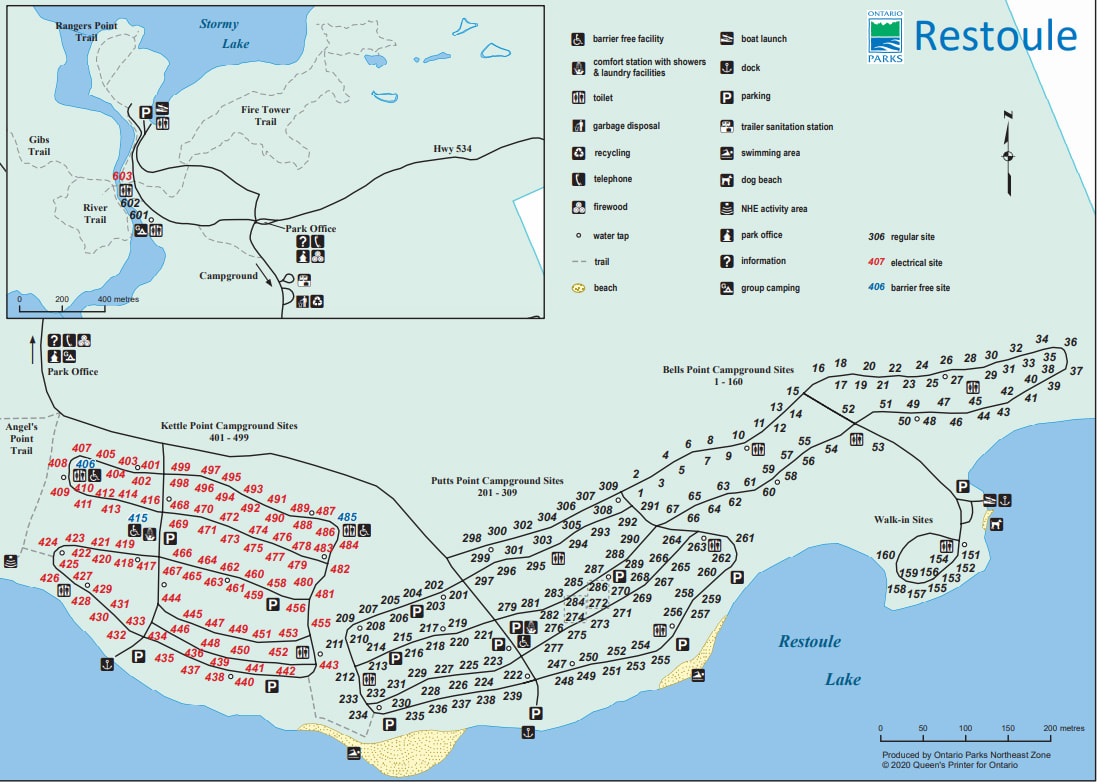
8818 Highway 534 Restoule, ON, Canada, P0H 2R0 (705)729-2010 No. of Sites (274) - 167 non-electrical sites, 97 electrical sites, 10 walk-in sites, 3 group sites. Wheel Chair Accessible Campsites - 3 Barrier-free sites, all of which are in the electrical section and next to a washroom Operating Dates: June 22, 2020 to October 13, 2020 |
Blog Entries: - Resting In Restoule - July 2020
- Just Keep Swimming, Just Keep Swimming - July 2020
- A Charm Of Dragonflies - July 2020
- Just Keep Swimming, Just Keep Swimming - July 2020
- A Charm Of Dragonflies - July 2020
Terrain: Good mixture of sun and shade under the deciduous and pine tree mix.
Staff: Friendly and professional
Bathrooms: Clean, and in good condition throughout the park. However, don't choose a site too close to them because sometimes the smell can carry over into your site if you are right next to them.
Shower: The showers were not in service at the time due to the Covid-19 pandemic.
Beach : There are two beaches in the park (3 if you count the pet beach). Both are sandy and good for kids to play at. There is one larger beach and one smaller one. The water level at the buoy lines at both beaches are not all that deep and you will often see adults crossing over them to swim in the deeper water. Many people will actually swim at the dog park instead because there are no buoy lines there at all and the water is clear and clean.
Out Door Water Faucets - Clean, drinkable water and easy to find throughout the park
Hiking Trails:
Fire Tower Trail – 4.1 km - 1.5 to 2 hrs
The “must do” hiking trail in Restoule. The trail meanders through some beautiful mature forests, travelling across boardwalks and rugged rocky ridges. The trail offers a great rest location and view point at Amber Lake, and also passes by a historic Fire Tower. After a challenging climb this trail will continue to impress with a spectacular view from atop the 100 meter high Stormy Lake Bluff.
The River Trail – 1.2 km - 30 mins
This trail takes you through the rolling topography of the west side of the Restoule River. It is a gently paced trail that will take you along the river and then through some beautiful mature forests.
Rangers Point Trail – 860 m - 20 mins
If you’re looking for a great way to spend the afternoon this short trail is perfect for a casual hike or bike ride. The trail provides access to two spectacular waterfront picnic sites with views of the Stormy Lake Bluff and historic Fire Tower.
Angels Point Trail – 2.8km - 1 hr
The Angel’s Point Trail (2.8 km) provides two mountain biking loops through vibrant hardwood forests. The inner loop is a single-track trail designed for mountain biking with smooth winding corners, moderate changes in elevation and flowing dips, humps and bumps. The outer double track loop is an easier option with a wide trail surface and fun rolling hills. The Rangers Point Trail is a 1 km double track trail with some steeper climbs and two great views of the Stormy Lake Bluff. Mountain bike rentals are available at the Park Office. For rental information see the Facilities page.
Gibs Trail – 8.1km - 3 to 3.5 hrs
This is an unmaintained trail and is only recommended for experienced explorers. Trail is an undeveloped linear backcountry trail that eventually leads out of the park into adjacent Crown lands. Once outside of the park it has several branches and dead ends. A GPS, compass, and accurate map are recommended if you plan to leave the park boundaries. Sections of this trail remain wet all season and several beaver dam crossings can add to the difficulty.
Pet Amenities - There is a nice little pet beach down by the boat launch in the Bell's Point section of the park. The water is clear and clean and great for swimming for both animals and humans alike. There are a couple of picnic tables to sit at if you don't want to go in the water.
Playground - There are no playgrounds at this park
Park Store - There is no park store in this park. For anything other than firewood you will have to make a 20 minute drive out of the park to the nearest store.
Boat/Canoe Rentals - Mountain bikes, canoes, kayaks, and paddleboards are available for rent at the Park Office.
Things To Do At Restoule Provincial Park
- Birding
- Mountain Biking (Angel’s Point Trail has two mountain biking loops through vibrant hardwood forests. The Rangers Point Trail is a double track trail with some steeper climbs and two great views of the Stormy Lake Bluff. )
- Fishing (Lake Trout, Splake, Walleye, Pike, Musky, Large and Smallmouth Bass, and Whitefish.)
- Swimming
- Hiking
- Picnicking
- Boating
- Canoeing
- Kayaking
- Stand Up Paddle Boarding
- Hunting (Time and location restrictions exist. Please contact the park directly for details and seasonal variations.)
- Discovery Programs for kids
Attractions And Places To Go Near Restoule Provincial Park
Closest City - Restoule, Ontario
- Board's Honey Farm
- Rockcliffe Pottery and Craft
- Crow's Nest Lodge (restaurant)
- Treasure's By The Lake Collectibles and Vintage Toys
Closest City - Restoule, Ontario
- Board's Honey Farm
- Rockcliffe Pottery and Craft
- Crow's Nest Lodge (restaurant)
- Treasure's By The Lake Collectibles and Vintage Toys
Directions:
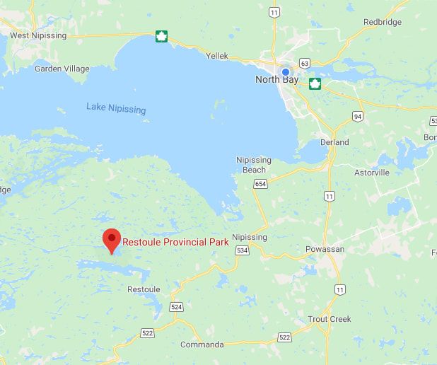
Restoule Provincial Park is situated about an hour to the south west of North Bay.
If you are coming from the north, follow Hwy 11 until you get to the turn off to Hwy 654. Follow Hwy 654 until you reach the turn for Hwy .534. The park is about 10 km down that hwy and is on the right hand side of the road.
If you are coming from the south, follow Hwy 11 until you get to the turn off to Hwy 522 in Trout Creek and go left. Follow this for about 48 km until you reach the turn off for Hwy 534. It will be on your right about 15 km down Hwy 534.
If you are coming from the west, follow Hwy 69 until you get to the turn off for Hwy 522. Follow Hwy 522 for about 80 km and then turn left onto Hwy 524. After about 5 km you will turn left onto Hwy 534. Follow Hwy 534 until you come to the park.
Signs For Directions To Park - There are not many signs to direct you to the park until you are practically on top of it. "Lady Google" is relatively accurate though. She is a little off and tells you that you are there slightly before you get there, but by that point you can't get lost.


